


Waterville Twp. Voting District, Le Sueur County, Minnesota
About
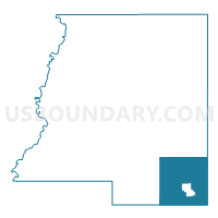
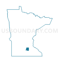
Outline

Summary
| Unique Area Identifier | 602904 |
| Name | Waterville Twp. Voting District |
| County | Le Sueur County |
| State | Minnesota |
| Area (square miles) | 33.72 |
| Land Area (square miles) | 30.53 |
| Water Area (square miles) | 3.19 |
| % of Land Area | 90.54 |
| % of Water Area | 9.46 |
| Latitude of the Internal Point | 44.25416700 |
| Longtitude of the Internal Point | -93.59579650 |
Maps

Graphs
Select a template below for downloading or customizing gragh for Waterville Twp. Voting District, Le Sueur County, Minnesota


Neighbors
Neighoring Voting District (by Name) Neighboring Voting District on the Map
- Blooming Grove Twp. Voting District, Waseca County, MN
- Cordova Twp. Voting District, Le Sueur County, MN
- Elysian Twp. P-1, Le Sueur County, MN
- Elysian Twp. P-2, Le Sueur County, MN
- Iosco Twp. Voting District, Waseca County, MN
- Kilkenny Twp. Voting District, Le Sueur County, MN
- Morristown Twp. Voting District, Rice County, MN
- Shieldsville Twp. Voting District, Rice County, MN
- Waterville Voting District, Le Sueur County, MN
Top 10 Neighboring County Subdivision (by Population) Neighboring County Subdivision on the Map
- Waterville city, Le Sueur County, MN (1,868)
- Shieldsville township, Rice County, MN (1,137)
- Elysian township, Le Sueur County, MN (1,046)
- Waterville township, Le Sueur County, MN (716)
- Morristown township, Rice County, MN (697)
- Iosco township, Waseca County, MN (550)
- Blooming Grove township, Waseca County, MN (525)
- Cordova township, Le Sueur County, MN (471)
- Kilkenny township, Le Sueur County, MN (404)
Top 10 Neighboring Place (by Population) Neighboring Place on the Map
Top 10 Neighboring Unified School District (by Population) Neighboring Unified School District on the Map
Top 10 Neighboring State Legislative District Lower Chamber (by Population) Neighboring State Legislative District Lower Chamber on the Map
- State House District 25B, MN (45,574)
- State House District 25A, MN (40,391)
- State House District 26A, MN (39,465)
- State House District 26B, MN (38,912)
- State House District 24B, MN (36,327)
Top 10 Neighboring State Legislative District Upper Chamber (by Population) Neighboring State Legislative District Upper Chamber on the Map
- State Senate District 25, MN (85,965)
- State Senate District 26, MN (78,377)
- State Senate District 24, MN (71,152)
Top 10 Neighboring 111th Congressional District (by Population) Neighboring 111th Congressional District on the Map
Top 10 Neighboring Census Tract (by Population) Neighboring Census Tract on the Map
- Census Tract 703, Rice County, MN (4,606)
- Census Tract 9503, Le Sueur County, MN (4,351)
- Census Tract 9504, Le Sueur County, MN (3,838)
- Census Tract 7901, Waseca County, MN (3,364)
- Census Tract 7903, Waseca County, MN (3,137)
Top 10 Neighboring 5-Digit ZIP Code Tabulation Area (by Population) Neighboring 5-Digit ZIP Code Tabulation Area on the Map
- 56093, MN (12,831)
- 56048, MN (3,898)
- 56096, MN (3,021)
- 55052, MN (2,090)
- 56028, MN (1,372)
- 56052, MN (699)